
1981 Report by R.J.PIKE and M.LANGDON
Introduction
Tidal erosion of the left bank of the River Parrett just north of the old Ford Passage on Combwich Common (Grid Ref.ST 261425) during the years 1969-77, revealed an occupation layer of dark humus, charcoal and lias stones in the river bank, 1.3 to 1.5 metres below the present ground level and extending for 36.5 metres. Romano-British potsherds and metal objects were picked up from the material washed out of the bank, and stones, apparently forming paving, wall footings and cobbling, burnt clay, potsherds and a hearth, were observed in the section.
A full excavation was not possible because of the danger of causing further erosion, but the site was watched by a member living nearby, finds collected, the exposed section cleared of mud and the traces of occupation measured and drawn from time to time, particularly after very high tides.
Pottery recovered from layers in the bank and from the river bed include sherds which can be dated to late 1st – early 2nd centuries, 2nd – 3rd centuries and to the late 3rd – 4th centuries. The only coin found, in the dark humus, is dated to the mid 4th century. A long period of occupation is therefore indicated, but it was not possible to identify separate periods of occupation in the building(s) seen. A late 3rd – 4th century date is probable for the final occupation and abandonment.
A good proportion of the finds were recovered from the mud below the bank and cannot be stratified. The sherds were, however, not abraded, and found only in the vicinity of the site, so are considered part of the occupation debris.
The Site
The occupation site is five miles north west of Bridgwater on the west bank of the tidal Parrett in the Parish of Otterhampton with Combwich. The flat valley of the Parrett is covered with Holocene clay and recent rive’ alluvium, overlying peat at four – six metres depth, with, below, deposits of gravel, peat and sand over the Lower Lias bedrock. At Combwich, the valley narrows with higher ground formed of Rhaetic and Lower Lias rock reaching the river on the west side, and with the extreme western end of the Polden Hills one mile away at Gaunts Farm, Pawlett. (Fig.1)
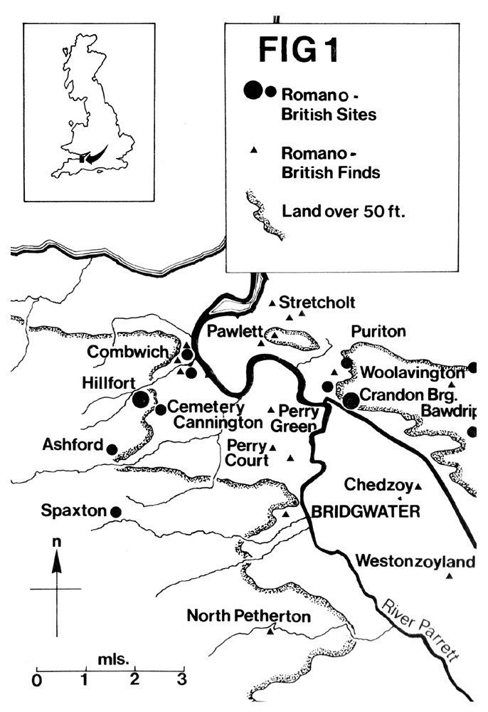
The site is half a mile north of the Romano-British settlement at Combwich found in excavation for clay pits by Mr.H.S.L.Dewar in 1937 (Dewar, 1940, 7). It is approximately one and a half miles from Cannington Hill Fort, where an excavation by Professor P. Rahtz in 1963 produced Roman and Pre-Roman Iron Age pottery, and a similar distance from the Cannington Cemetery east of the Hill Fort excavated by Professor Rahtz in 1962/63 (Rahtz, 1969, 56). Other Romano-British settlements in the area of the lower Parrett are shown on Fig.1. These include two recently discovered on low lying ground at Perry Court Farm and at Perry Green, Wembdon, both sites approximately two miles from Combwich.
The occupation level at Combwich Common lies on blue Holocene clay with 1.3 – 1.5 metres of alluvium above, which is comparable with the situation at Mr.Dewar’s site and at Perry Green. The ground level at Combwich Common at 6.5 metres O.D. is similar to that at Perry Green and I metre lower than Mr. Dewar’s site. Combwich Common can be covered with water at Spring tides, as there is no protecting bank.
There was until early this century, a ferry at Combwich passage, and a layer of hard rock in the river bed enabled horses and wagons to cross the ford at low tide, within the memory of older local inhabitants.(Gresswell 1922, p.186).Reference is made to a medieval chapel at the ford in a book on Somerset circa 1820 (The Rev. Nightingale, c.1820) but this is not proven and there is now no trace of a building. Present erosion shows that the river is moving its bed towards the high ground to the west and wooden steps on the west bank connected with the old ferry, visible in 1960, have now gone. Sherds of Romano-British pot recently found in a drainage trench on the road bounding the Common, 150 metres west of the site on the bank (information Mrs. Temple) indicate that the settlement may extend in that direction. Examination of the east bank of the river opposite the site has failed to reveal any traces of occupation.
It is therefore thought probable that the course of the river in the Roman period lay some two or three hundred metres to the east. If the sill of hard rock continues in that direction, a ford could have existed then, connecting with the North Somerset Herepath (Grundy 1930). A river crossing in use from Saxon times onwards connecting the Combwich settlement and the high ground to the west with the so-called Roman road along the crest of the Polden Hills from Pawlett to the Fosse Way seems feasible; this was discussed by Professor Rahtz (Rahtz 1969).
The low-lying situation of the settlements at Combwich and Perry Green suggests that there must have been some rise in water levels since the 4th century. A marine inundation has been considered (Rahtz 1969, Cunliffe 1966 and Kelting 1968), but local flooding by rivers, the sea and perhaps a climatic change, rather than a large inundation, is now suggested (Hawkins 1971).
The site was observed over a period of eight years during which the west bank receded by almost two metres. No trace of the settlement is now visible, but a buried ground surface at the same level, with occasional stones and flecks of charcoal, can still be traced.
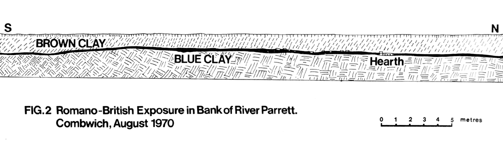
Fig.2 shows the section as seen in 1970/71, with the layer of humus and stones scattered at its base; the thickness of the occupation layer varied from 100 mm to 270mm. The stones formed a feature which could have been a wall base, with paving to the south and a hearth, perhaps with cobbling, to the north. The hearth, 3 metres north of the ‘wall’ was 0.9 metres long and 150 mm thick; it had been completely removed by 1972. Nails, an iron rafter or tile pin, unidentified pieces of iron and a quantity of daub, point to timber structures on a stone base.
The dimensions of the occupation seen from observation is estimated as approximately 36 metres x 2 metres, but a western part may have been lost before the site was noticed.
The Finds
Deposited in the Blake Museum, Bridgwater.
Metal Objects
Included, in addition to the iron objects mentioned above , a bronze coin, very corroded, identified as Constans A.D.227-41, a bronze spoon, in possession of a former member of the Society, and copper slag, of which 450g. was collected. More was seen in the mud. Lead objects included 60g. of fragments and a groma weight or plumb bob, (Fig.3).
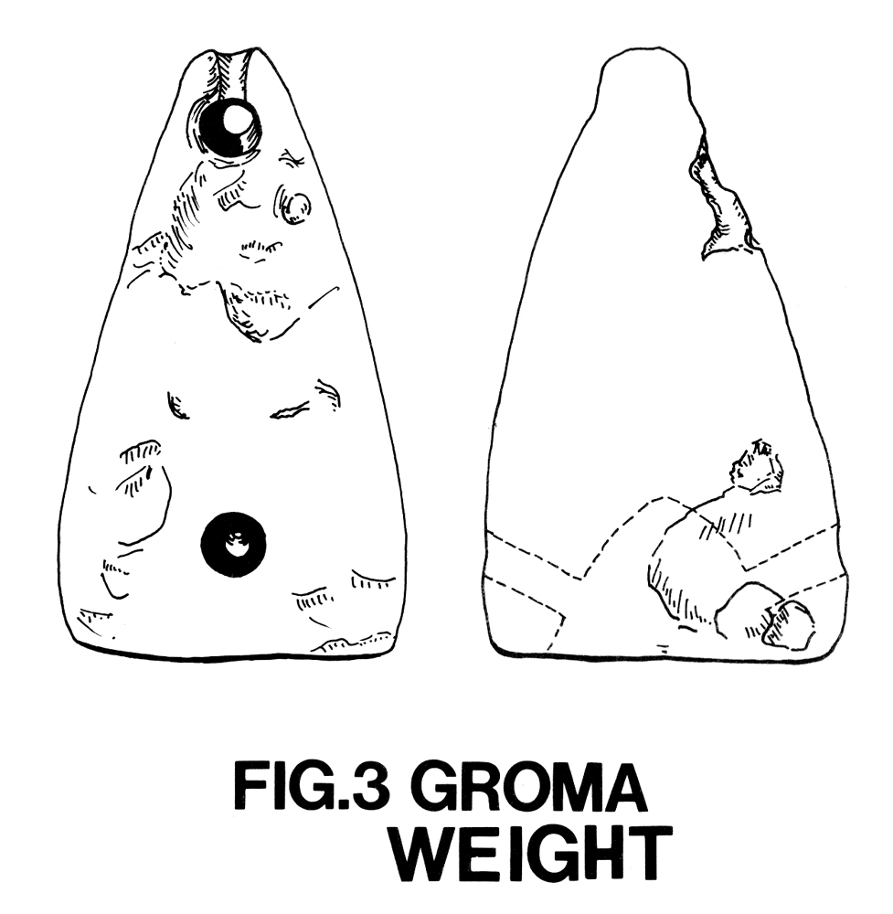
This, weighing 425g and 70mm long from apex to centre of base, is well made and shows an advanced technique. The use of the groma in Roman land surveying is described by O.A.W. Dilke (1971). No exact parallel for this object is known, but a conical weight or plumb bob in bronze was found by A.&.V Rae at Cramond Roman Fort (Rae A.& V. 1974, Fig.14.12).
Stone
The finds included building stones of lias, rounded and flat sandstone and quartzite pebbles, probably obtained from the seashore near Steart, small round sandstone pebbles up to 35mm long (possibly sling stones) and fragments of Tertiary Keuper sandstone and Devonian grits, from the slopes of the Quantocks. Hone stones of fine grained sandstone, one with two incised marks, and a clean cut, approx. 100 mm thick slab of Devonian Morte slate must have been used for some domestic purpose. Lias roof tiles, one with a well cut rebate, five pieces of floor tile in reddish material with calcite and quartz inclusions and a quantity of coal were collected.
Bones and Shells
Approx. 1/2 kilo weight of animal bones was collected; they were very fragmented and most had been split lengthwise. They included long bones, shoulder and teeth of sheep, ox and pig, teeth of horse and small bones of rabbit or hare. Oyster, limpet and whelk shells were found in the occupation levels.
Pottery
Finds were compared with that from other Romano-British sites in the lower Parrett valley, e.g. Bush Marsh, Bawdrip, Combwich, Cannington, Perry Court, Perry Green and Westonzoyland. Similarities in fabric and form in some of both the late and early pottery were observed: (see detailed report below).
The latest date for pot found at this site is provided by red colour coated bowls of Oxford manufacture, A.D. 270-400 and black burnished cooking pots with wide everted rims, dated to the 4th century.
The period of occupation was similar to that at Mr. Dewar’s clay pit site, i.e. from the late 1st until the 4th centuries, but no pits or levels below the layer of stone and humus could be found, and pottery of all dates was found in the occupation level. It was observed that, at this site, as at Bush Marsh, wheel made grey ware sherds and large, heavy storage jars formed a considerable part of the finds. At this site, however, fine red wares such as Samian and the later Oxford wares were not abundant.
84% of the pottery finds occurred between 1969 and 1972, as the bank eroded, with 16% only in the next 5 years. This may indicate that the main part of the site lay to the east, or that ditches or rubbish pits may have been on that side. The matter cannot now be resolved,
The proportions of wheel made grey wares, dated to the 3-4th centuries is large, about 60% of the total of all black burnished and grey pot. The proportion of pottery dateable to the late 1st- early 2nd centuries is 5.4% of total in the first 4 years and 5.2% overall, not a significant difference. It appeared to be residual all over the site. A calculation of sherd weights from the stony part of the occupation layer south of the ‘wall footing’ and from the northern part near the hearth, however, appeared to show that the earlier (residual) sherds comprised approximately 10% of the total found in the bank south of the ‘wall’ and 22% in the northern area. This can be regarded as a slight indication only of the possible whereabouts of the earlier part of the settlement.
Description of Pottery
Specific sherds are described and, where numbered, illustrated in Figs. 5 and 6.
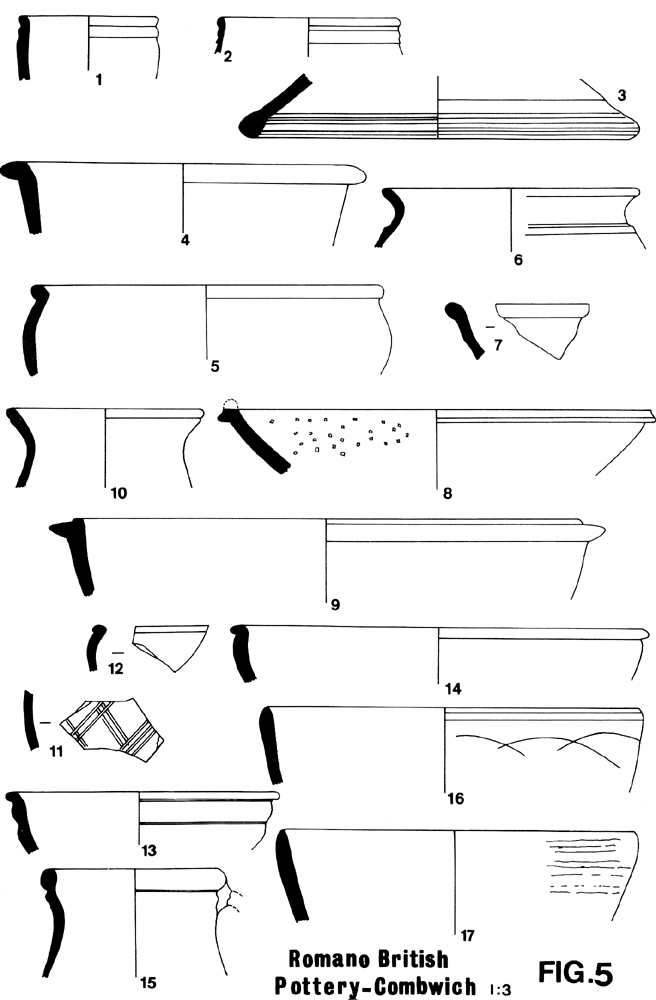
From Occupation Levels in the Bank
- Rim sherd of small jar or beaker in soft reddish fabric with angular grey and black inclusions, wheel made. Vessels in similar fabric and shape found in late 1st/early 2nd century levels at Bush Marsh, Puriton. (M.5 Report in preparation).
- Rim sherd of small beaker with grooved horizontal decoration in oxidised sandy soft fabric, possibly Severn Valley ware. The style is similar to beaker Camerton No.307 (Wedlake 1958) and p.86 Westonzoyland (Miles 1969) dated to the 1st/early 2nd century.
- Lid fragment in wheel turned hard grey ware. Similar to lids found at Bush Marsh and at Mr.Dewar’s site (Leech 1977, Fig.13,24). Date up to 2nd century.
- Flat rimmed dish in quartz gritted, black burnished fabric, similar to Bush Marsh Type Fabric 22 or Exeter Type Fabric 40 (Information Paul Bidwell). Date up to end of 2nd century (Gillam 1976). Similar flat rimmed bowls were found at Mr.Dewar’s site. (Leech 1977 Fig.13, 25,26).
- Rim of bowl. Rim flattish, everted, and bowl sides curved. Fine micaceous grey ware similar to tankards at Mr.Dewar’s site (Leech 1977) and to Type Fabric 15 at Bush Marsh. Form not parallelled; possibly 2nd century.
- Cavetto rim of small shouldered cooking pot in wheel made fine light grey ware. Probably locally made. The form may be late 2nd/3rd century.
- Rim sherd of colour coated bead rim bowl. Oxford manufacture copying Samian Form 31, late 3rd to 4th century. Type C.45 (Young, 1977).
- Mortarium rim sherd, in colour coated red ware with small flange and multi-coloured grits. Probably Oxford manufacture, similar to Young’s type C, 100 A.D.300-400 (Young 1977). Oxford colour coated bowls and mortaria are found at both Bush Marsh and Dewar’s Combwich site (Leech 1977).
- Rim of dish with flanged rim, in black burnished ware Cat.1 (Farrar 1973 75-6). Similar to Gillam’s type 229 350-400 A.D. (Gillam 1968)
- Double bead rim sherd of flagon in fine hard grey ware, wheel made. Probably Congresbury Type A, late 3rd-4th century (Gray Usher and D.Lilly 1964).
Not illustrated are sherds of black burnished cooking pots with acute angled lattice decoration, pre mid-3rd century, (Farrar 1973), a sherd of soft sandy grey ware with cordoned decoration, probably 2nd century and a plain rim sherd of a Samian bowl discoloured by fire. A small sherd of red painted parchment ware was probably Oxford manufacture.
From spoil an river bank
- 11. Cooking pot bodysherd in fine soft sandy black burnished ware with incised lattice decoration.Style similar to Farrar 1973, Fig.1 (5) but the fabric is the same as Bush Marsh Type Fabric 13, not quartz gritted
- 12. Half bead rim sherd of small bowl with curved sides and horizontal incised decoration, in soft dusty grey fabric, similar to No.5 above. Similar fabric at Dewar’s site (Leech 1977 Fig.13, 19). Shape similar to P.58 Westonzoyland (Miles, 1969). Late 1st/2nd century
- 13. Rim sherd of bowl in hard grey ware with burnish on outisde. Cordoned decoration and small everted rim.Wheel made. Fabric and date similar to Nos.5 and 12 above
- 14. Rim and side of small bowl with curved sides and deeply incised groove under bead rim. Soft micaceous grey fabric similar to Bush Marsh Type Fabric No.9. Wheel made. Similar to P.99 at Westonzoyland and Fig.14, 18, Exter (Fox A. 1952).
- 15. Neck sherd of flagon with handle broken off, in a very gritty hard grey ware. Similar to Gatcombe Fig.18, 271 (Branigan 1977), said to be of Congresbury manufacture, but this vessel is not wheel made and is probably of local manufacture
- 16. Plain rim of bowl or casserole lid in black burnished fabric Cat.1 with slight indentation on outer rim and intersecting arc decoration. Similar to Nos. 82 or 91 (Gillam 1976). Also similar to P.80 Westonzoyland (Miles 1969). 4th century.
- 17. Plain rim of bowl, wheel made with no decoration in a hard fine grey fabric with black burnish inside and out. Possibly a local product; this fabric is parallelled at Bush Marsh (Type Fabric 21), Westonzoyland and in the Highbridge area (Information R.Nash). 4th century
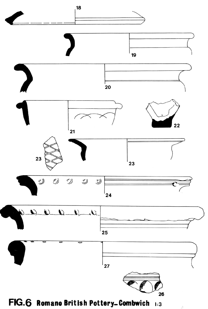
- 18. fragment in black burnished ware Cat.1 (Farrar 1973). Similar are found at Mr. Dewar’s site (Leech 1977, Fig.13, 24) and at Bush Marsh. Late 1st/2nd century.
- 19. Rim and neck sherd of cooking pot in hand gritty grey micaceous fabric, wheel made. No decoration visible, but otherwise, with cavetto rim, upright neck and shoulder,similar to P.88 Westonzoyland (Miles 1969). Probably 2nd century. Local manufacture.
- 20. Rim sherd of large heavily made pot or storage jar. Hard grey fabric with some quartz grits, similar to 19 above, wheel made, burnished on outside Date as No.19.
- 21. Flanged rim sherd of dish with curvilinear ornament in black burnished ware. Cat.1 (Farrar 1973). Similar to No.91 (GiIlam 1976). Dated late 4th century.
- 22. Pedestal base fragment of jar or flagon in very hard sandy grey fabric with very little mica. Traces of black burnish or slip inside and out. Could be of New Forest manufacture. Late 3rd to 4th century.
- 23. 4 sherds were found of widely everted cooking pot rims and flattish lattice. Date from No.147 (Gillam 1968) late 3rd – late 4th century.
- 24. Rim sherd of large storage jar in hard grey fabric similar to fabric of Nos.19 and 20 above with triple beading on heavy rim and stab marking on inside of rim. Locally made.
- 25. Rim sherd of very large storage jar with roughly made overturned jabbed decoration inside rim. Large jars in a similar coarse heavy fabric full of quartz and sandstone fragments (Bush Marsh Type Fabric 44) are found at Bush Marsh (M.5 report in preparation). Locally made.
- 26. Body sherds of large storage jar with thumb printed decoration below neck. Similar vessels in this sandy fabric with rounded quartz and dark slaty inclusions are found at Bush Marsh (Type Fabric a.M.45) Also probably made locally.
Not illustrated are plain colour coated bowls as No.7 above, flat rimmed dishes as No.4 and flanged rimmed dishes with no decoration, as No.9.
- 27. Rim sherds of very heavy storage jar with folded grooved rim and slash decoration inside rim, in muddy grey brown fabric with quartz grits, almost identical vessels in this fabric (Bush Marsh Type Fabric 46 )at Bush Marsh, Puriton
Conclusion
The site described in this report appears to be part of a rural settlement with houses of stone, timber and daub, situated on or near the river. Domestic animals used for food, together with shellfish, hone stones and some slag indicate a rural riverside site. The position, however, with its proximity to other settlements at Combwich, Cannington and Wembdon, suggests an area of fairly heavy population from the 1st to 4th centuries A.D.
As already discussed, Combwich occupied a favourable position for trade with a short sea route to South W ales, a sea route north towards Gloucester and the Midlands, river transport along the tidal Parrett, and, across a ford, a road connection with the Fosse Way, Ilchester and the settlements in that area.
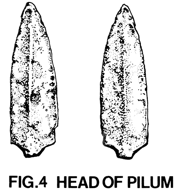
There is as yet, no definite evidence for military occupation in the lower Parrett valley, but air photography shows field markings on Otterhampton Hill at ST 263429 where a resistivity survey by Society Member Mr. D.W. Wallace in 1970 indicated the existence of an oblong structure, and on Pawlett Hill at ST 296428. Any speculations about military encampments or signal stations has not been substantiated and there is scope for much field work. However, a pilum or javelin head (Fig.4) was found near Combwich village at ST 256420, 30-40 cms. below the surface , in 1962/63 (identified by Mr. P. Rahtz at Cannington Hill excavations). The existence of this object and of the lead groma weight may point to some military and/or surveying organisation.
The civilian authority and the economics of the settlements in the lower Parrett valley are still a mystery; a port could well have existed as suggested by Professor Rahtz (Rahtz 1969). Some settlements seem to have been of considerable size. Mr. Dewar estimated 6 acres for his Combwich settlement (Dewar 1940), and the Bush Marsh, Puriton, settlement, as at present known, extends over about 500 x 400 metres.
The similarities in pottery mentioned in the pottery report indicate contact and probably trade between the various settlements. The early micaceous grey wares, black burnished wares, Oxford and New Forest pottery show that materials were coming into the area. The very large storage jars, common to Combwich and Bush Marsh, may be a local method of storage but, items e.g. corn, may have been traded.
The existence of the lias roof tiles, red floor tiles and cut slabs of Devonian rock at Combwich show some expertise in local building. It is interesting to speculate how and from whence the coal was obtained.
Occupation of the low lying sites shows that the valley must have been well drained with farm land for cattle, sheep and pigs, possibly corn. Timber and stone would have been readily available.
The date and cause for the ending of the Parrett valley settlements is still unknown. The same types of late 4th century pottery occur at all sites, but this, like the lack of coinage, does not give any real indication of how long the sites continued to exist after A.D.400. Professor Rahtz found evidence of a re-occupation of Cannington Hillfort with Roman pottery and structures and suggested that, as the Cannington cemetery produced material of late Roman and later date, a sub-Roman culture could have continued in the area until the mid-7th century. (Rahtz 1969).
This still leaves the question of when and how the lowland sites were abandoned and where the sub-Roman inhabitants lived. A local legend of raids and destruction by fire may relate to Viking rather than to late Roman attacks. The building at the site appears to have been destroyed by fire, but that may have been a domestic disaster. Worsening climate and flood may have rendered the lowland sites untenable; but the question still remains, where are the 5th – 7th century habitations? As already stated, much more is still to be learned about this part of Somerset.
Acknowledgements
The authors wish to thank Mr.M.Ponsford for assistance in identification of the groma weight, Mrs.J.Gill for assistance and advice in drawing finds and members of the Society for assistance in watching and clearing the site.
REFERENCES
- Branigan Dr. D. 1977’Gatcombe Roman Villa’ British Arch. Reports 44, 84-5
- Cunliffe Prof.B. 1966 ‘The Somerset Levels in the Roman Period’ Rural Settlements in Roman Britain, CBA Research Report No.7, 68-73.
- Dewar, H.S.L. 1940 ‘A Romano-British Settlement at Combwich’ Proc. Som. Arch. Soc. 86, 7 129-133.
- Dilke O.A.W. 1971 ‘The Roman Land Surveyors; an introduction to the Agrimensores’ 15.
- Farrar R.A.H. 1973 ‘Techniques and Sources of Romano-British Black Burnished Ware’ CBA Research Report 10 Edit.A. Detsicas 67-103.
- Fox A. 1952 ‘Roman Exeter’, Manchester, Fig.14, No.18.
- Gillam J.P. 1968 ‘Types of Roman Coarse Pottery Vessels in Northern Britain’ Oriel Press, Newcastle. 1976 ‘Coarse Fumed Ware in North Britain and Beyond’. Glasgow Arch. Journal.
- Greswell Rev.W.H.P 1922 ‘Dumnonia and the Valley of the Parrett’ 186.
- Grundy G.B. 1950 ‘The Ancient Highways of Somerset’ Arch. Journal XCVI 105, p.281.
- Hawkins Dr. A.B. 1971 ‘Sea Level changes around South West England’ Colston Papers Vol.XXIII 75-85
- Kelting E.L. 1968 ‘The Rivers and Sea Walls of Somerset’ Proc. Som. Arch. Soc.112 13-14.
- Leech R.H. 1977 ‘Romano-British Rural Settlement in South Somerset and North Dorset’ Bristol University Doctoral Thesis Fig.13.
- Miles H & T. 1969 ‘Settlement Sites of the late Pre-Roman Iron Age in the Somerset Levels. Proc. Som. Arch. Soc.113 32-38.
- Nightingale The Rev.1820 ‘Description of the County of Somerset Etc’ 588
- Rae, A &V. 1974 ‘The Roman Fort at Cramond’ Br itannia Vol.5 195, Fig.14,12.
- Rahtz, P. 1969 ‘Cannington Hillfort 1963’ Proc. Som. Arch. Soc.113, 56-68
- Usher, Gray & 1964 ‘A Romano-British Pottery Kiln at Congresbury’ Lilly, D. Proc. Som. Arch. Soc. 108, 172-75
- Wedlake W.J. 1958 ‘Excavations at Camerton, Somerset’ 160, 167 Fig.41.
- Young C.J. 1977 ‘Oxfordshire Roman Pottery’ British Arch. Reports 43, 158-9, 174-5.